
Date:21 July 2025
Oasis Circular No.:2504
Subject: Update on Fishery Farms around the Chinese Coast
Ships have been reminded to watch out for the fishery farms when calling Chinese ports, especially those where claims for fishery farm damages caused by ships have been frequent.
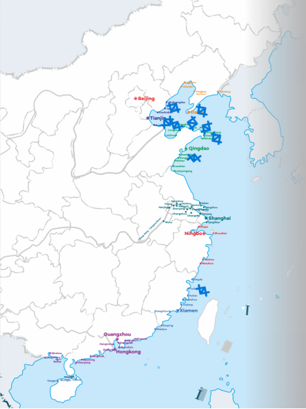
Coastal map with ports where fishery farm claims occur frequently
We hereby summarize the latest situation regarding fishery farms at these ports for the reference of the ships that plan to call these ports.
Dalian
In the map below, we have highlighted in red the area where recent fishery farm claims nearby Dalian occurred, defined by the following eight coordinates:
38°53.513'N, 122°03.333'E
38°53.988'N, 122°02.907'E
38°54.754'N, 122°03.423'E
38°55.787'N, 122°04.449'E
38°57.355'N, 122°11.263'E
38°56.963'N, 122°11.69'E
38°55.507'N, 122°9.512'E
38°53.405'N, 122°5.48'E
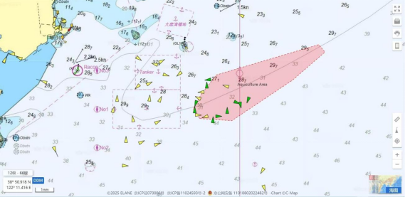
Illustration of fishery farm areas nearby Dalian
This area is located to the east of Dayaowan anchorage, where ships usually anchor before calling Dalian or ports nearby.
From Oct 2024, AIS reflectors indicating “Aquaculture Area **” for those fishery farms in the waters nearby Dayaowan anchorage were installed, in order to alert passing by ships. However, it should be noted that not all fishery farms are installed with such devices.
Tianjin
Most of the fishery farms nearby Tianjin are mudflat aquaculture in shallow water, which have little impact on oceangoing ships. In recent years, a couple of fishery farm claims occurred in the area marked in red in the map below, defined by the following four coordinates:
39°19.570'N,119°37.725'E
39°19.430'N,119°38.580'E
39°15.861'N,119°36.901'E
39°15.973'N,119°36.160'E
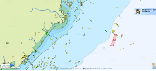
Illustration of fishery farm areas nearby Tianjin
This area is relatively far from the coast and the seawater depth reaches around 20m. Ships proceeding to ports such as Tianjin, Jingtang, Qinhuangdao and Huanghua may pass by this area.
Yantai
According to the navigation alert published by Shandong MSA on 12 Jan 2024, there are numerous fishery farms to the south of the public navigation waterway between Yantai and Weihai, defined by the following four coordinates and highlighted in light green in the map below:
37°38'39" N, 121°38'48" E;
37°39'24" N, 121°56'30" E;
37°34'30" N, 121°45'20" E;
37°33'24" N, 121°38'48" E.
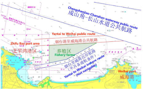
Illustration of fishery farm areas nearby Yantai
Laizhou
A satellite remote sensing monitoring of marine aquaculture for Laizhou ports shows that there are many fishery farms in the area which are very close to the navigation channels and anchorages, as shown in the map below
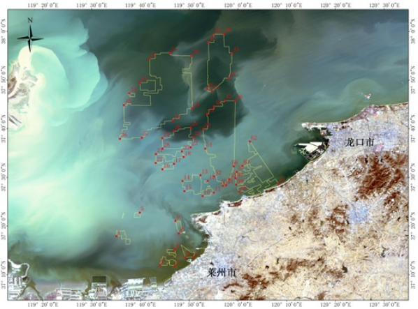
Illustration of fishery farm areas nearby Laizhou
The coordinates for the major fishery farms boundaries are listed as follows:
No. | N(°) | E(°) |
1 | 37.2986 | 119.5853 |
2 | 37.1995 | 119.7341 |
3 | 37.1974 | 119.7858 |
4 | 37.2529 | 119.7840 |
5 | 37.3793 | 119.6648 |
6 | 37.2264 | 119.8201 |
7 | 37.2278 | 119.8478 |
8 | 37.3079 | 119.7983 |
9 | 37.3508 | 119.7869 |
10 | 37.4358 | 119.8798 |
11 | 37.4477 | 119.9177 |
12 | 37.4876 | 119.8971 |
13 | 37.5069 | 119.8723 |
14 | 37.4872 | 119.8111 |
15 | 37.4530 | 119.8175 |
16 | 37.5275 | 119.7423 |
17 | 37.5457 | 119.7817 |
18 | 37.5697 | 119.8146 |
20 | 37.5888 | 119.8088 |
21 | 37.5796 | 119.7202 |
22 | 37.5494 | 119.7193 |
23 | 37.6030 | 119.8386 |
24 | 37.6375 | 119.8485 |
25 | 37.6702 | 119.8386 |
26 | 37.6586 | 119.7807 |
27 | 37.6339 | 119.7420 |
28 | 37.5985 | 119.7427 |
29 | 37.7362 | 119.8440 |
30 | 37.9169 | 119.8417 |
31 | 37.9260 | 119.7680 |
32 | 37.9060 | 119.6982 |
33 | 37.8238 | 119.6650 |
34 | 37.7877 | 119.6290 |
35 | 37.7471 | 119.6106 |
36 | 37.6319 | 119.5972 |
37 | 37.6360 | 119.6717 |
38 | 37.6942 | 119.7785 |
39 | 37.9909 | 119.9517 |
40 | 37.9906 | 119.9170 |
41 | 37.9626 | 119.8988 |
42 | 37.8026 | 119.8950 |
43 | 37.7956 | 119.9113 |
44 | 37.8396 | 119.9689 |
45 | 37.9257 | 119.9796 |
46 | 37.7618 | 119.9909 |
47 | 37.7627 | 119.9548 |
48 | 37.7430 | 119.9186 |
49 | 37.7169 | 119.8948 |
50 | 37.6653 | 119.8818 |
51 | 37.5985 | 119.8887 |
52 | 37.5033 | 119.9191 |
53 | 37.4708 | 119.9490 |
54 | 37.4727 | 119.9593 |
55 | 37.4935 | 119.9710 |
56 | 37.5375 | 119.9857 |
57 | 37.5185 | 119.9963 |
58 | 37.4968 | 119.9922 |
59 | 37.4746 | 119.9943 |
60 | 37.4508 | 120.0059 |
61 | 37.4781 | 120.1385 |
62 | 37.6224 | 120.0410 |
63 | 37.5391 | 120.0157 |
Rizhao& Lanshan
In the latest port guide published by local authorities, the areas where most of the fishery farms are located are circled in red in the below map.
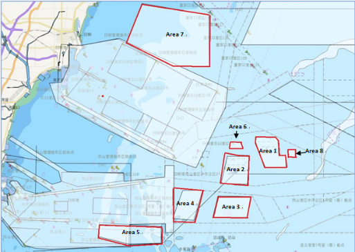
Illustration of fishery farm areas nearby Rizhao & Lanshan
The eight areas are defined by the following coordinates:
(1) Area 1 is bounded bythe line joining following eight points:
35°12'31 "N, 119°57'59" E;
35°12'31 "N, 120°00'43" E;
35°12'05 "N, 120°01'08" E;
35°10'23 "N, 120°01'15" E;
35°10'25 "N, 120°02'08" E;
35°09'02 "N, 120°02'16" E;
35°08'59 "N, 119°59'15" E;
35°11'57 "N, 119°57'59" E.
(2) Area 2 is bounded by the line joining following four points:
35°10'18 "N, 119°54'04" E;
35°10'07 "N, 119°57'05" E;
35°07'07 "N, 119°56'52" E;
35°07'12 "N, 119°53'12" E.
(3) Area 3 is bounded by the line joining following four points:
35°05'46 "N, 119°52'46" E;
35°05'42 "N, 119°57'19" E;
35°03'20 "N, 119°56'48" E;
35°03'20 "N, 119°52'04" E.
(4) Area 4 is bounded by the line joining following four points:
35°06'24 "N, 119°47'53" E;
35°06'26 "N, 119°50'39" E;
35°03'00 "N, 119°49'26" E;
35°03'13 "N, 119°46'29" E.
(5) Area 5 is bounded by the line joining following five points:
35°02'31 "N, 119°36'19" E;
35°02'12 "N, 119°44'51" E;
35°00'23 "N, 119°44'52" E;
35°00'18 "N, 119°40'19" E;
35°01'08 "N, 119°36'08" E.
(6) Area 6 is bounded bythe line joining following four points:
35°11'56.896 "N, 119°54'32.466" E;
35°11'56.954 "N, 119°56'01.152" E;
35°11'12.346 "N, 119°56'13.709" E;
35°11'12.272 "N, 119°54'19.914 "E.
(7) Area 7 is bounded bythe line joining following five points:
35°27'42"N, 119°42'12" E;
35°23'12"N, 119°40'00" E;
35°20'33 "N,119°46'32" E;
35°20'31"N, 119°51'33"E;
35°26'25"N, 119°51'31" E.
(8) Area 8 is bounded bythe line joining following four points:
35°11'06"N, 120°02'30" E;
35°11'06"N,120°03'30" E;
35°10'12 "N,120°03'30" E;
35°10'12"N, 120°02'30"E.
Penglai
According to the navigation alert published by local MSA in 2022, there are fishery farms to the west of the outer anchorage of the port, an area defined by the following coordinates:
37°57'54"N, 120°48'48"E;
37°58'00"N, 120°51'48"E;
37°57'42"N, 120°52'42"E;
37°55'24"N, 120°52'42"E;
37°52'48"N, 120°49'30"E;
37°52'56"N, 120°46'42"E;
37°55'00"N, 120°46'22"E;
37°55'53"N, 120°46'22"E;
37°55'54"N, 120°48'43"E.
Longkou
According tothe navigation alert published by local MSA in 2022, there are fishery farms to the west of the outer anchorage of the port, an area defined by the following coordinates:
37°41'30"N, 120°12'20"E;
37°50'00"N, 120°12'20"E;
37°50'00"N, 120°23'42"E;
37°43'50"N, 120°25'16"E.
Weihai
Fishery farm claims also occur from time to time in Weihai. Local MSA issued a navigation alert; however, the coordinates of the farm area were not identified.
Ningde & Kemen
In recent years, more and more fishery farm claims occurred in Ningde and Kemen. The map below shows the locations of the fishery farms which we have collected from local sources as well as from cases we have handled in these areas.
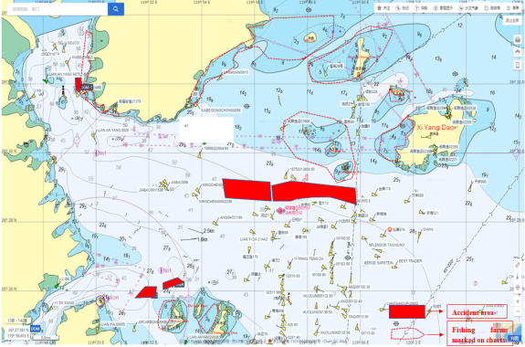
Illustration of fishery farm areas nearby Ningde & Kemen
Recommendations to ships:
1. Please note that the above-mentioned locations of fishery farms are not meant to be exhaustive, accurate or permanent, as they are seasonal and can change from time to time without notice. Therefore, ships are strongly suggested to collect the latest fishery farm information from the local agent in advance, check the updated chart and navigation alerts issued by local authorities, and maintain enhanced lookout when navigating in these areas.
2. It is also strongly recommended that ships navigate in the official recommended channels when accessing these ports. Generally speaking, the chance for fishery farms to exist in the official channels and customary routes is slim, but this possibility cannot be entirely ruled out. Extra caution is still required.
3. If possible, avoid entering into or departing from these ports or anchorages during nighttime or periods of poor visibility.
4. Maintain a proper lookout at all times during navigation, checking AIS and radar while maintaining visual lookout. Many of the fishery farms don’t have AIS or radar reflectors; on the other hand, some of the fishing nets are below the water surface and may be difficult to observe visually.
We hope the above guidance will be of assistance. If there is any query, please feel free to contact us at oasis@oasispandi.com at any time.
Best regards,
Oasis P&I Services Company Limited
Copyright 2017 All Rights Reserved Oasis P&I Services Ltd. 沪ICP备88888888号
